


Powerful Winter Storm in New York and Neighboring States: More Than 20 Million US Residents at Risk
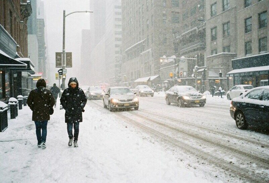
Photo: Travel And Tour World
New York and neighboring states in the eastern United States will come under the impact of a powerful winter storm in the coming hours, reports Travel And Tour World, citing national meteorological services. Heavy snowfall, icing, and extremely dangerous travel conditions are expected. Forecasters warn that this could become a serious weather test and lead to large-scale disruptions to transport and urban infrastructure.
How the Storm Is Forming
The sharp deterioration in weather conditions is linked to the movement of a powerful atmospheric system that previously brought extreme precipitation to the US West Coast and is now shifting eastward. As it advances, it collides with a cold Arctic air mass over the central part of the country, leading to the rapid intensification of the cyclone.
This combination of factors creates conditions for heavy snowfall, strong winds, and a sharp drop in temperatures. Meteorologists note that the primary threat to the region lies in the storm’s rapid development and the pace of precipitation, especially during the evening and nighttime hours.
An additional hazard comes from persistent freezing temperatures that will remain after the precipitation weakens. As a result, snow and ice will melt slowly, and slippery conditions on roads and sidewalks may persist long after the snowfall ends.
Critical Days
According to forecasters, the active phase of the storm will begin in the second half of Friday. Snowfall will intensify rapidly by evening and reach peak strength overnight. This period is expected to bring the most dangerous travel conditions due to the combination of heavy precipitation, wind, and sharply reduced visibility.
By Saturday morning, snowfall is expected to weaken, although light precipitation may continue through midday. Freezing rain is possible in some areas. Meteorologists do not expect a significant improvement in conditions due to persistently low temperatures that will prevent snow and ice from melting.
On Sunday, a brief warm-up is forecast, with temperatures rising to 40°F (around +4°C), but forecasters caution that this will only be a temporary pause. In the final days of December, the region may face another wave of Arctic cold, which would again increase icing risks and complicate the return to normal daily life after the storm.
Where the Heaviest Snowfall Is Expected
The most intense precipitation and the formation of a stable snow cover are forecast for New York, with snowfall totals of 4 to 8 inches (10–20 cm), which already poses serious risks to transport and urban infrastructure in the мегаполис. Difficult weather conditions are also expected in northern New Jersey, southern areas of Connecticut, and the Hudson Valley. In the mountainous regions of the Catskills and the Poconos, snowfall could reach 8–12 inches (20–30 cm).
In southern New Jersey and the eastern part of Long Island, precipitation will be less intense and may partially transition into a mix of snow, rain, and sleet. In these areas, snow accumulation is estimated at 2–4 inches (5–10 cm), with an elevated risk of icy conditions.
Risks and Recommendations
The greatest challenges are expected in the transport sector. During the peak of the storm, delays and cancellations are possible at regional airports, along with disruptions to commuter rail services and subways, as well as severe congestion on major highways. An additional threat comes from the risk of power line outages caused by the accumulation of wet snow and ice. Authorities advise residents to be prepared for short-term power outages and to check heating systems in advance.
Drivers are advised to reduce speed, allow extra travel time, and closely monitor local traffic alerts. Non-essential travel, especially during Friday evening and overnight hours, is best avoided.
Emergency services also urge residents to stock up on food, water, and medications in advance, and homeowners to check heating systems and keep flashlights and warm clothing on hand. Particular attention should be paid to official warnings and timely forecast updates.
Conclusion
In recent years, New York and its surrounding areas have seen a shortage of significant snowfalls, notes CBS News. If the forecast of 10–20 cm of snow is confirmed, this would mark the city’s heaviest snowfall since late January 2022, when a powerful coastal storm dropped about 22 cm in Central Park.
The scale of the current storm goes beyond a local event: more than 23 million US residents could be affected. December has already been marked by a series of weather disruptions that led to widespread air travel disruptions across the country. In one episode, more than 6,128 flight delays and 109 cancellations were recorded in a single day at airports in Chicago, Denver, Los Angeles, Washington, Boston, Portland, Cleveland, and Charlotte. During the next incident, schedules for more than 10,000 flights were altered, another 879 departures were canceled, and reports included Atlanta, Detroit, Orlando, Miami, and Los Angeles. As a result of the most recent large-scale disruption, delays affected around 6,000 flights, and 132 departures were canceled at airports from Denver to Salt Lake City.
Analysts at International Investment note that the combination of extreme weather conditions and already overloaded transport infrastructure once again highlights the vulnerability of US transportation systems during peak periods. Even short-lived weather shocks can quickly escalate into large-scale disruptions, with consequences felt far beyond the immediate impact zone.
Подсказки: USA, New York, winter storm, snowfall, ice, severe weather, transport disruptions, aviation, infrastructure